


EVOLVING COMMUNITY
COMPREHENSIVE PLAN: CHAPTER 3
OVERVIEW
Since 1990, Meridian has experienced exponential growth, becoming the second largest city in Idaho and one of the top ten fastest growing cities in the nation. Due to the desirability of the area, population growth will continue. Over the last 20 years, property in and around Meridian has changed from primarily agricultural and single-family residential to include a more diverse mix of residential types and commercial and industrial uses. That trend will continue as land traditionally used for agriculture develops at urban intensities. However, the foremost goals will remain to grow the city as a premier place to live, work, and play.
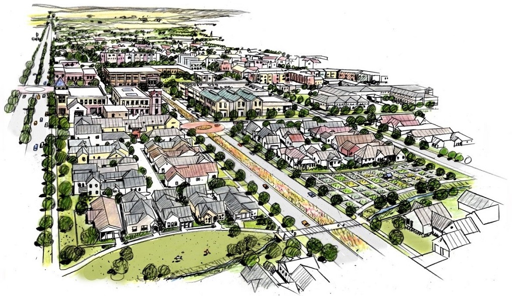
The Plan embraces Meridian as an Evolving Community by focusing on strategically planning for future growth. It provides new land use tools to ensure strategic and sustainable growth through the provision of services and infrastructure consistent with this Plan’s vision. Essential to community health is the promotion of responsible land use and growth by ensuring that development pays for itself and enhances the quality and character of the community. Reinventing key areas, supporting infill, and focusing growth in strategic areas support an efficient and high-quality development pattern that aligns with the availability and capacity of services and infrastructure.
As part of the Evolving Community Vision, the following elements are included in this chapter:
EVOLVING COMMUNITY VISION
A community thoughtfully adapting to changes.
GROWTH AND POPULATION
INTRODUCTION
The Growth and Population element reinforces the City’s commitment to meet and protect the needs of existing residents and businesses in tandem with future population growth and land development. Policies in this section address how to plan for the redevelopment of properties already within the corporate boundaries of the City and its Area of City Impact, and guide growth to priority areas, all while protecting private property rights.
BACKGROUND
Understanding the implications of changing demographics and population projections enables a community to anticipate and effectively plan for future market conditions and how best to meet its residents’ future needs. COMPASS, the agency responsible for regional transportation planning, estimates that by 2040 the regional population total will exceed 1 million people. At the center of all this, very conservative estimates put Meridian’s population at over 160,000 people in the same time period. COMPASS updates these numbers yearly to reflect recent growth. As Meridian continues to grow and respond to development pressure, it is important to employ tools and planning protocols that guide responsible development and the expansion of public utilities and services.
The City of Meridian’s leaders and staff adopt and enforce policies and regulations that govern the City, in addition to applicable state and federal laws. Meridian is committed to authentic citizen engagement in government through participation on boards, commissions, and committees, as well as through public feedback as part of planning initiatives.
Area of City Impact
In accord with § 67-6526 of Idaho Code, unincorporated properties within the City’s Area of City Impact (AOCI) are governed by Ada County for day-to-day administration of zoning matters. However, there is an agreement between Ada County and Meridian for the Area of City Impact. This agreement states that the current Meridian Comprehensive Plan will apply within the City’s established AOCI.
Within the AOCI, the county has generally applied a Rural Urban Transition (RUT) zone which permits five-acre-lot, single-family residential development, as well as agricultural-related uses and a range of conditional uses. County development applications within the AOCI are reviewed by the City of Meridian for compliance with the comprehensive plan and applicable City policies.
The City of Meridian desires, over time, all development within its Area of City Impact to be served with urban services from the City of Meridian. Such services primarily include sanitary sewer, water, reclaimed water, fire, police, and parks. Secondarily, the City considers the availability and capacity of the school system, transportation facilities, libraries, and storm water facilities in any review of development within the AOCI. All requests for annexation into the City limits will require that the owner extend City-owned services at the time of development.
The importance of cooperating with Ada County and neighboring cities is imperative to successful long-term land use, transportation, and utility planning. There are very significant financial and quality-of-life implications for not doing so. As such, the City of Meridian is committed to fulfilling the terms of its Area of City Impact Agreement with Ada County and coordinating with adjacent service providers.
Meridian aims to guide growth in a way that efficiently expands infrastructure and services to support sustainable growth patterns. Targeting the right development and growing responsibly – in the right locations with the right services – is the foundation of the Evolving Community Vision.
Plans for specific areas, corridors, and infrastructure provide the next level of detail for implementation of the vision, including Urban Renewal Districts and Opportunity Zones. These following policies address utility and service expansion, transportation, quality development, fiscal impact, and compatibility with Meridian’s Unified Development Code, among other attributes the community values regarding growth and population.
Property Rights
The City of Meridian respects the rights of its citizens and their property, and is committed to counter negligence, abuse or devaluing of private property by others. Residents should feel their private property rights are respected and secure. See Appendix C for a checklist used in reviewing proposed regulations or actions to ensure compliance with private property rights.
For additional information, refer to the following resources:
- Existing Conditions Report; Addendum to the City of Meridian Comprehensive Plan | City of Meridian Webpage
- Ada County Code, Title 9, Chapter 4: Meridian Area of City Impact | External Website
- Communities in Motion 2040 2.0 | City of Meridian Webpage
- Appendix C: Regulatory Takings Checklist | City of Meridian Webpage
FUTURE LAND USE
INTRODUCTION
The Future Land Use element emphasizes the importance of thoughtful and responsible land use planning, cooperation, and collaboration among the various jurisdictions and agencies in the area, and preservation and enhancements of the high quality of life that currently exists in Meridian. The policies in this section are graphically represented in the Future Land Use Map.
BACKGROUND
Planning in a deliberate manner, with an understanding of market, financial, and physical realities, can help foster a healthy balance of land uses and minimize uncertainty for officials, staff, residents, and others. Land use planning is an important tool in attracting and retaining the residents, businesses, and visitors that sustain the community’s economy and contribute to a city’s high quality of life. As such, it is important to continually evaluate what changes are needed to ensure that the community grows the way it desires.
The location and balance of land uses and densities should be efficient and sustainable; enhance community identity; support a multimodal transportation network; provide housing choices near jobs, schools, shops, and parks; minimize conflicts between incompatible uses; and integrate development with existing and planned infrastructure. See the Transportation element in the Connectivity Chapter of this Plan for more information on Transportation and Land Use Integration.
For additional information, refer to the following resources:
- Existing Conditions Report; Addendum to the City of Meridian Comprehensive Plan | City of Meridian Webpage
- ACHD Transportation and Land Use Integration Plan | External Website
Transportation, Land Use, and Corridors
The transportation network plays an especially critical role in the location, types, and balance of land uses across the City. Two types of corridors that are particularly relevant to the land use policies are defined below. (See Chapter 6)[https://meridiancity.org/planning/compplan/connected] for more on transportation and land use integration.
Key Multimodal Corridors: These corridors have land uses with the potential to support future multimodal transportation, including transit.
- Fairview Avenue/Cherry Lane
- Meridian / SH-69
- Railroad Corridor
- Overland Road
- Ten Mile Road
- Eagle Road Corridor
Key Transportation Corridors: These corridors are important for regional connectivity and community identity, and may require special land use considerations.
- Chinden
- Ustick
- Fairview/Cherry
- Franklin
- Railroad Corridor
- Overland
- Linder
- Lake Hazel
- Highway 16
- Ten Mile
- Meridian
- Eagle
FUTURE LAND USE MAP
Mapping future land uses is a key component of the Comprehensive Plan, so that development occurs in the direction and manner most desired by the community.
The Future Land Use Map (FLUM) identifies the vision for a portfolio of land uses to implement the City’s many diverse goals and objectives, and works in conjunction with the text of the Comprehensive Plan, City Code and various policies of the City. In addition, the FLUM is closely aligned with ACHD’s Master Street Map (MSM). The MSM is the transportation equivalent of the City’s Future Land use Map and reflects a built-out collector and arterial street network. The FLUM is not a zoning map and differs in that the FLUM describes the character and type of use that is desired in the future and not necessarily what is currently in place. The FLUM depicts a built-out Meridian that is very diverse in residential densities, commercial and industrial land uses as well as civic/public opportunities.
Descriptions of the various future land use designations that appear on the FLUM are described on the following pages. The FLUM is shown in Appendix D.
Symbols
All “future” symbols shown on the Future Land Use Map, such as parks, schools, fire and police stations, transit stations, etc., represent generalized locations based on the best information the City has to date. All such symbol locations are to be considered conceptual and not exact locations. All “existing” symbols shown on the Future Land Use Map for parks, schools, fire and police stations, etc. represent precise locations based on the facilities in place at the time of Plan adoption.
General Guidance
Future Land Use designations are not parcel specific. An adjacent, abutting designation, when appropriate and approved as part of a public hearing with a land development application, may be used. A designation may not be used however, across planned or existing collector or arterial roadways, must not be used on a parcel not directly abutting the designation, and may not apply to more than 50% of the land being developed. All other changes to designations must be approved through a Comprehensive Plan Map Amendment. Sample zoning listed in the future land use designation descriptions does not preclude the use of other zoning districts provided the proposed project is consistent with the description of the land use designation.
Difference Between Future Land Use and Zoning
The Comprehensive Plan’s Future Land Use descriptions and map work in tandem with the Plan’s policies to help direct development patterns citywide to achieve the #MyMeridian Vision. They determine the desired character of new development, range of densities allowed, and intensity and mix of uses.
- The City of Meridian Unified Development Code (UDC) defines a series of zoning districts that are much more specific in terms of allowed uses and other development and operational requirements than future land use designations.
- The future land use designations help determine what type of zoning new development may receive when a project applies for annexation into the City, or what allowances exist for a property to rezone. However, the future land use designations and zoning districts are not a one-to-one with each other. Some future land use designation descriptions in this chapter include sample zoning. Sample zoning listed does not preclude the use of other zoning districts provided the proposed project is consistent with the description of the land use designation.
- Contact the Meridian Planning Division for more information on what zoning districts typically apply to the various Future Land Uses.
RESIDENTIAL LAND USES
The purpose of this designation is to provide for a variety of housing types and densities varying from large estate or semi-rural lots to multi-family homes. In all cases, urban services such as sewer, water, parks, and emergency services should be provided. Residential designations are described in following pages.
Within residential areas the following ideas and policies shall apply:
- The Comprehensive Plan encourages a variety of product types and lot sizes within every neighborhood.
- Gross residential densities are rounded to the nearest whole number.
- At the discretion of City Council, areas with a Residential Comprehensive Plan designation may request an office use if the property only has frontage on an arterial street or section line road and is two acres or less in size. In this instance, no ancillary commercial uses shall be permitted.
Low Density Residential
This designation allows for the development of single-family homes on large and estate lots at gross densities of three dwelling units or less per acre. These areas often transition between existing rural residential and urban properties. Developments need to respect agricultural heritage and resources, recognize view sheds and open spaces, and maintain or improve the overall atmosphere of the area. The use of open spaces, parks, trails, and other appropriate means should enhance the character of the area. Density bonuses may be considered with the provision of additional public amenities such as a park, school, or land dedicated for public services.
Medium Density Residential
This designation allows for dwelling units at gross densities of three to eight dwelling units per acre. Density bonuses may be considered with the provision of additional public amenities such as a park, school, or land dedicated for public services.
Medium High Density Residential
This designation allows for a mix of dwelling types including townhouses, condominiums, and apartments. Residential gross densities should range from eight to twelve dwelling units per acre. These areas are relatively compact within the context of larger neighborhoods and are typically located around or near mixed use commercial or employment areas to provide convenient access to services and jobs for residents. Developments need to incorporate high quality architectural design and materials and thoughtful site design to ensure quality of place and should also incorporate connectivity with adjacent uses and area pathways, attractive landscaping and a project identity.
High Density Residential
This designation allows for the development of multi-family homes in areas where high levels of urban services are provided and where residential gross densities exceed twelve dwelling units per acre. Development might include duplexes, apartment buildings, townhouses, and other multi-unit structures. A desirable project would consider the placement of parking areas, fences, berms, and other landscaping features to serve as transitions between neighboring uses. These areas are compact within the context of larger neighborhoods and are typically located around or near mixed use commercial or employment areas to provide convenient access to services and jobs for residents. Developments need to incorporate high quality architectural design and materials and thoughtful site design to ensure quality of place; they should incorporate connectivity with adjacent uses and area pathways, attractive landscaping, gathering spaces and amenities, and a project identity.
COMMERCIAL LAND USES
This designation will provide a full range of commercial uses to serve area residents and visitors. Desired uses may include retail, restaurants, personal and professional services, and office uses, as well as appropriate public and quasi-public uses. Multi-family residential may be allowed in some cases, but should be careful to promote a high quality of life through thoughtful site design, connectivity, and amenities. Sample zoning include: C-N, C-C, and C-G.
OFFICE LAND USES
This designation will provide opportunities for low-impact business areas. These uses would include professional offices, technology and resource centers; ancillary commercial uses may be considered (particularly within research and development centers or technological parks). Sample zoning include L-O.
INDUSTRIAL LAND USES
This designation allows a range of uses that support industrial and commercial activities. Industrial uses may include warehouses, storage units, light manufacturing, flex, and incidental retail and offices uses. In some cases uses may include processing, manufacturing, warehouses, storage units, and industrial support activities. Sample zoning include: I-L and I-H.
OLD TOWN LAND USES
This designation includes the historic downtown and the true community center. The boundary of the Old Town district predominantly follows Meridian’s historic plat boundaries. In several areas, both sides of a street were incorporated into the boundary to encourage similar uses and complimentary design of the facing houses and buildings. Sample uses include offices, retail and lodging, theatres, restaurants, and service retail for surrounding residents and visitors. A variety of residential uses are also envisioned and could include reuse of existing buildings, new construction of multi-family residential over ground floor retail or office uses.
The City has developed specific architectural standards for Old Town and other traditional neighborhood areas. Pedestrian amenities are emphasized in Old Town via streetscape standards. Additional public and quasi-public amenities and outdoor gathering area are encouraged. Future planning in Old Town will be reviewed in accordance with Destination Downtown, a visioning document for redevelopment in Downtown Meridian. Please see Chapter 2 Premier Community for more information on Destination Downtown. Sample zoning include O-T.
MIXED USE LAND USES
In general, the purpose of this designation is to provide for a combination of compatible land uses within a close geographic area that allows for easily accessible and convenient services for residents and workers. The intent is to promote developments that offer functional and physical integration of land uses, to create and enhance neighborhood sense of place, and to allow developers a greater degree of design and use flexibility.
Uses can be mixed vertically, such as a building with retail on the ground floor and offices above, or horizontally, such as a healthcare center with a mix of doctor offices, pharmacy, beauty salon, assisted care facilities, and apartments. Mixed use areas tend to have higher floor area ratios (less area devoted to parking), open space, and interconnected vehicular and pedestrian networks. A Mixed Use designation is typically used to identify a key area within the City which is either infill in nature or situated in a highly visible or transitioning area where innovative and flexible designs are encouraged.
There are five sub-categories of the Mixed Use designation that are used throughout the City: Neighborhood, Community, Regional, Interchange, and Non-Residential. This section further describes the purpose, intent, and development standards for these sub-categories. In addition, there are three sub-categories of the Mixed Use designation that are solely used in the Ten Mile Interchange Specific Area: Commercial, Residential, and Lifestyle Center. Mixed Use designations in the Ten Mile Interchange Specific Area are different than those throughout the rest of the City and are not subject to this section. For detailed descriptions of the land use designations in the Ten Mile area, go directly to the Ten Mile Interchange Specific Area Plan.
For the purposes of the Mixed Use section, the City identifies five different land use types:
- commercial (includes retail, restaurants, etc.);
- office;
- residential;
- civic (includes public and quasi-public open space, parks, entertainment venues, etc.); and,
- industrial.
All development in Mixed Use areas fall within one of these five categories. Industrial uses are typically discouraged in residential mixed use areas. However, if the developer can demonstrate that industrial uses are compatible and appropriate in Mixed Use Regional (MU-R), Mixed Use Non-Residential (MU-NR), or Mixed Use Interchange (MU-I) areas, the City will consider industrial uses when proposed as part of a larger Mixed Use development.
In reviewing development applications, the following items will be considered in all Mixed Use areas:
- A mixed use project should include at least three types of land uses. Exceptions may be granted for smaller sites on a case-by-case basis. This land use is not intended for high density residential development alone.
- Where appropriate, higher density and/or multi-family residential development is encouraged for projects with the potential to serve as employment destination centers and when the project is adjacent to US 20/26, SH-55, SH-16 or SH-69.
- Mixed Use areas are typically developed under a master or conceptual plan; during an annexation or rezone request, a development agreement will typically be required for developments with a Mixed Use designation.
- In developments where multiple commercial and/or office buildings are proposed, the buildings should be arranged to create some form of common, usable area, such as a plaza or green space.
- The site plan should depict a transitional use and/or landscaped buffering between commercial and existing low- or medium-density residential development.
- Community-serving facilities such as hospitals, clinics, churches, schools, parks, daycares, civic buildings, or public safety facilities are expected in larger mixed use developments.
- Supportive and proportional public and/or quasi-public spaces and places including but not limited to parks, plazas, outdoor gathering areas, open space, libraries, and schools are expected; outdoor seating areas at restaurants do not count.
- Mixed use areas should be centered around spaces that are well-designed public and quasi-public centers of activity. Spaces should be activated and incorporate permanent design elements and amenities that foster a wide variety of interests ranging from leisure to play. These areas should be thoughtfully integrated into the development and further placemaking opportunities considered.
- All mixed use projects should be accessible to adjacent neighborhoods by both vehicles and pedestrians. Pedestrian circulation should be convenient and interconnect different land use types. Vehicle connectivity should not rely on arterial streets for neighborhood access.
- A mixed use project should serve as a public transit location for future park-and-ride lots, bus stops, shuttle bus stops and/or other innovative or alternative modes of transportation.
- Alleys and roadways should be used to transition from dissimilar land uses, and between residential densities and housing types.
- Because of the parcel configuration within Old Town, development is not subject to the Mixed Use standards listed herein.
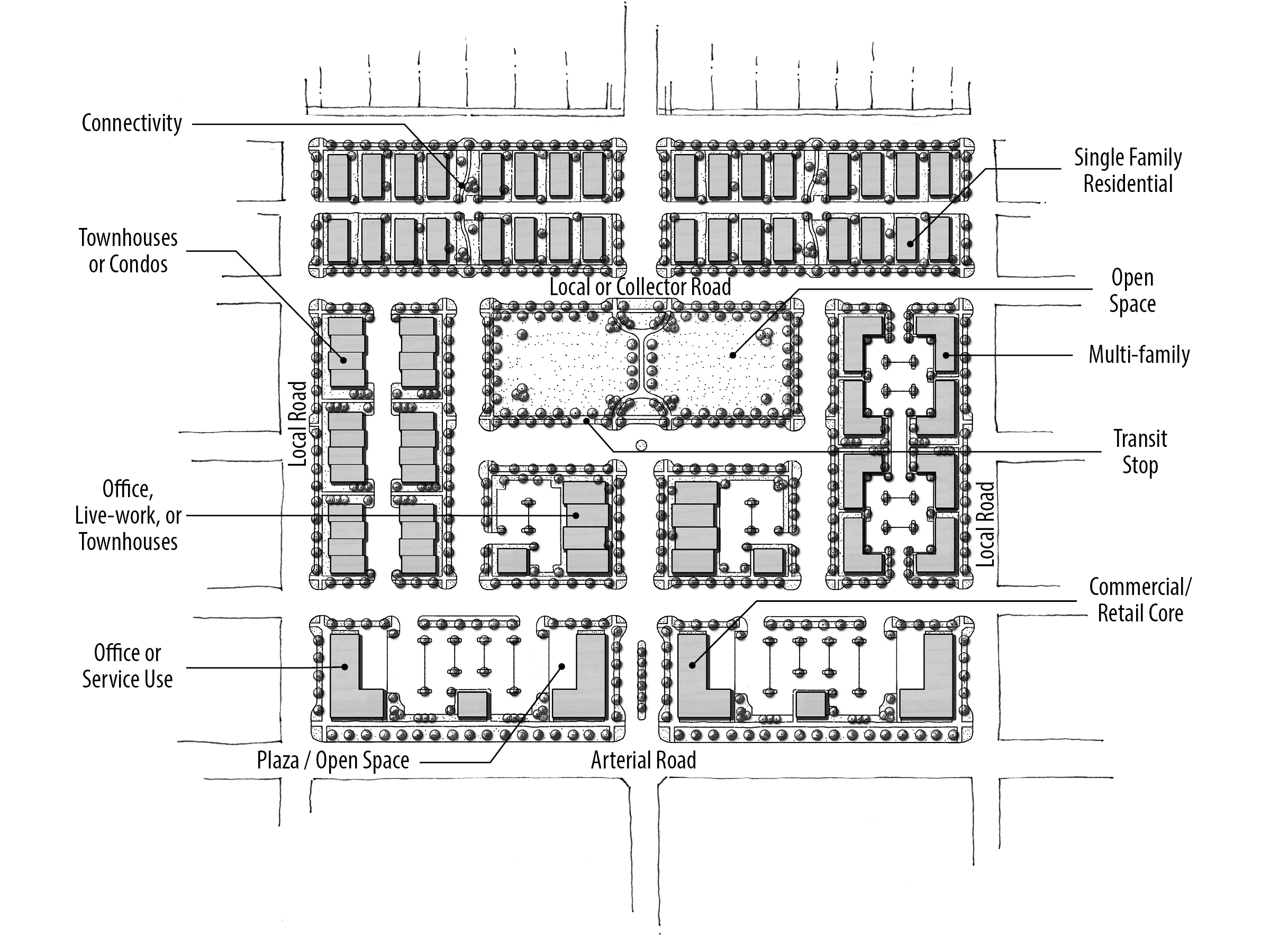
Mixed Use Neighborhood (MU-N)
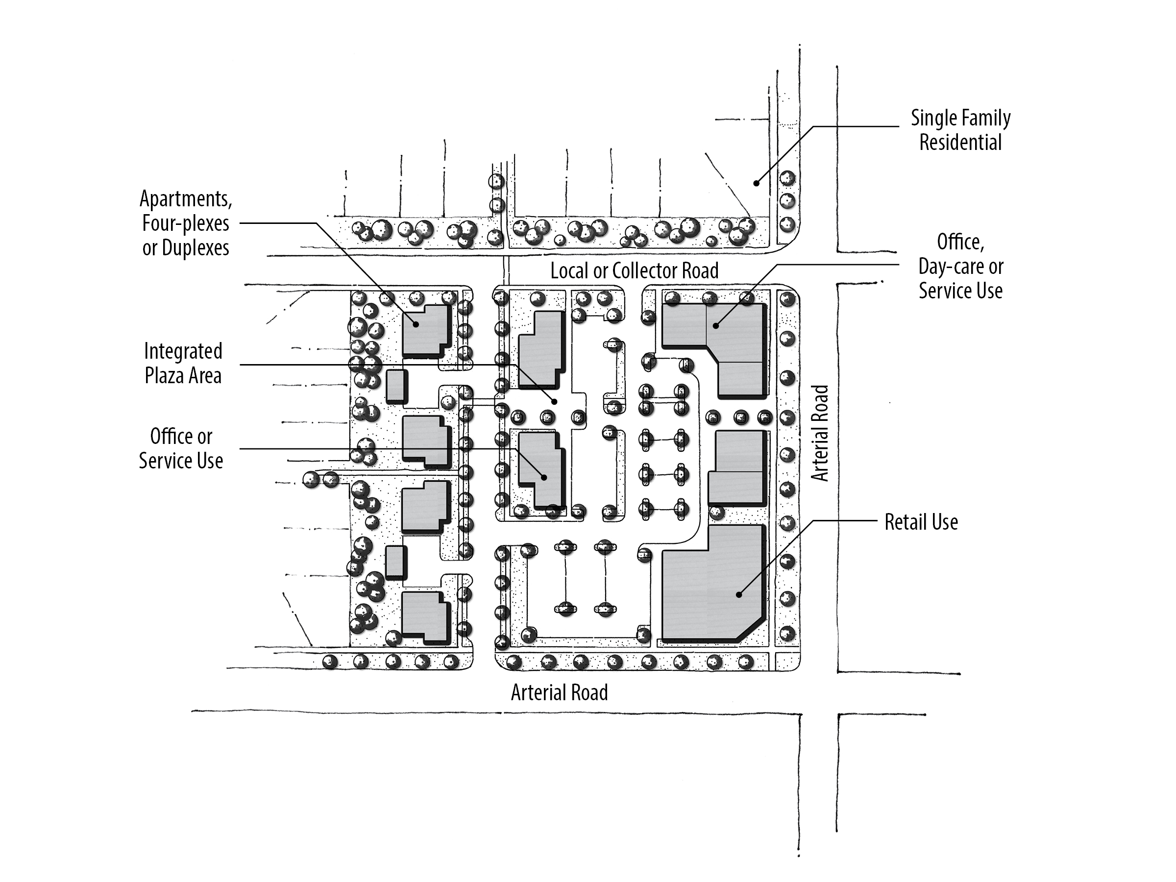
The purpose of this designation is to assign areas where neighborhood-serving uses and dwellings are seamlessly integrated into the urban fabric. The intent is to avoid predominantly single-use developments by incorporating a variety of uses. Land uses in these areas should be primarily residential with supporting non-residential services. Non-residential uses in these areas tend to be smaller scale and provide goods or services that people typically do not travel far for (approximately one mile) and need regularly. Employment opportunities for those living in the neighborhood are encouraged. Connectivity and access between the non-residential and residential land uses is particularly critical in MU-N areas. Tree-lined, narrow streets are encouraged. Developments are also encouraged to be designed according to the conceptual MU-N plan depicted in Figure 3B.
In reviewing development applications, the following items will be considered in MU-N areas:
- Development should comply with the items listed for development in all Mixed Use areas.
- Residential uses should comprise a minimum of 40% of the development area at gross densities ranging from 6 to 12 units/acre.
- Non-residential buildings should be proportional to and blend in with residential buildings.
- Three specific design elements should be incorporated into a mixed use development: a) street connectivity, b) open space, and c) pathways.
- Unless a structure contains a mix of both residential and office, or residential and commercial land uses, maximum building size should be limited to a 20,000 square-foot building footprint. For the development of public school sites, the maximum building size does not apply.
- Supportive and proportional public and/or quasi-public spaces and places such as parks, plazas, outdoor gathering areas, open space, libraries, and schools should comprise a minimum of 10% of the development area. Outdoor seating areas at restaurants do not count towards this requirement.
- Where the development proposes public and quasi-public uses to support the development above the minimum 10%, the developer may be eligible for additional residential densities and/or an increase to the maximum building footprint.
- A straight or curvilinear grid or radiating street pattern is encouraged for residential areas, and most blocks should be no more than 500’ to 600’ long, similar to Old Town or Heritage Commons; larger blocks are allowed along arterial streets.
Sample uses appropriate in MU-N areas include: alley-loaded single-family homes, townhouses, multi-family developments, neighborhood grocer, drug stores, coffee/sandwich/ice-cream shops, vertically integrated buildings, live-work spaces, dry cleaner/laundromat, salons/spas, daycares, neighborhood-scale professional offices, gift shops, schools, parks, churches, clubhouses, public uses, and other appropriate neighborhood-scale uses. Sample zoning include: R-8, R-15, TN-R, TN-C, L-O, and C-N.
Mixed Use Community (MU-C)
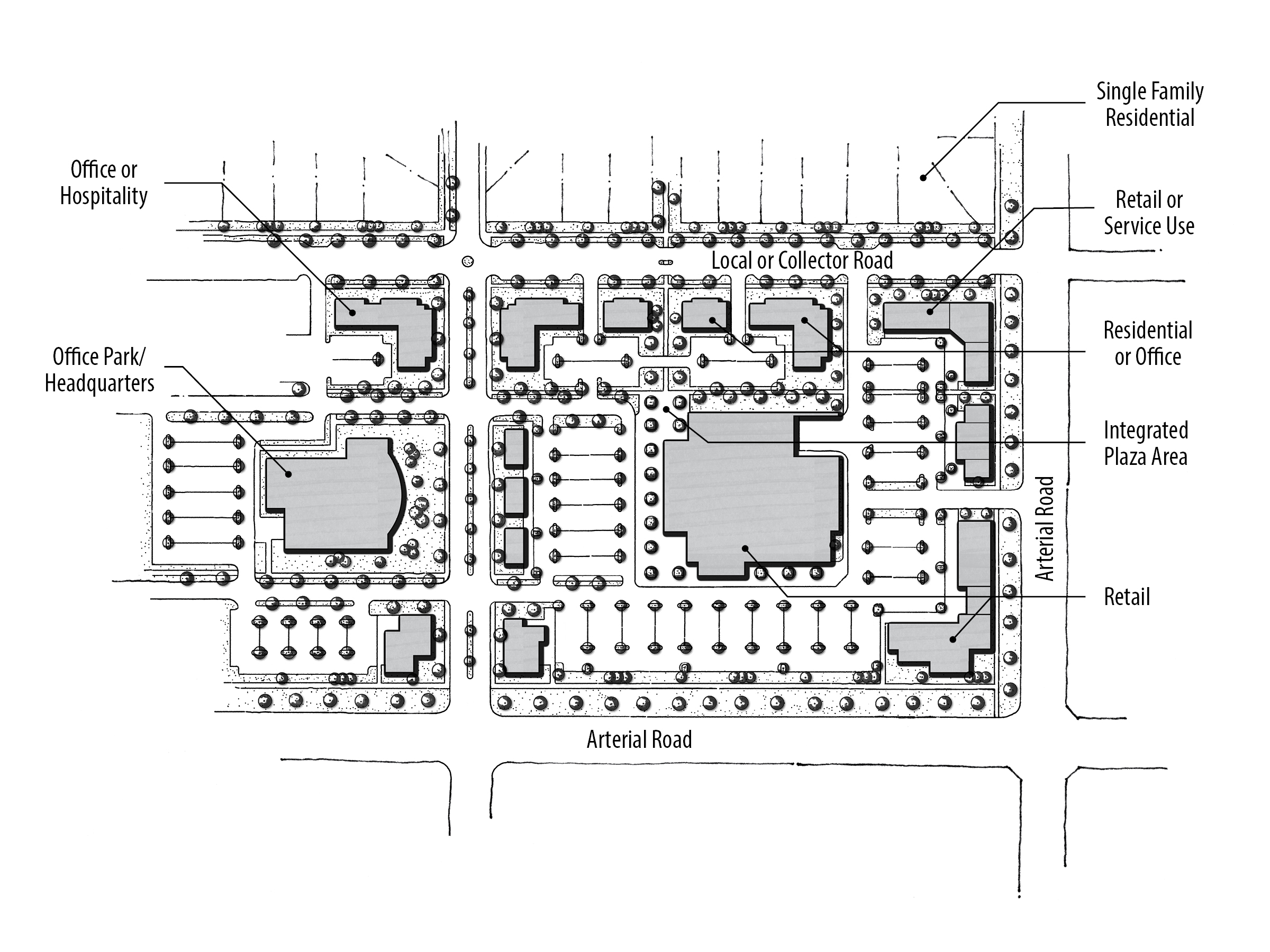
The purpose of this designation is to allocate areas where community-serving uses and dwellings are seamlessly integrated into the urban fabric. The intent is to integrate a variety of uses, including residential, and to avoid mainly single-use and strip commercial type buildings. Non-residential buildings in these areas have a tendency to be larger than in Mixed Use Neighborhood (MU-N) areas, but not as large as in Mixed Use Regional (MU-R) areas. Goods and services in these areas tend to be of the variety that people will mainly travel by car to, but also walk or bike to (up to three or four miles). Employment opportunities for those living in and around the neighborhood are encouraged. Developments are encouraged to be designed according to the conceptual MU-C plan depicted in Figure 3C.
In reviewing development applications, the following items will be considered in MU-C areas:
- Development should comply with the general guidelines for development in all Mixed Use areas.
- All developments should have a mix of at least three land use types.
- Residential uses should comprise a minimum of 20% of the development area at gross densities ranging from 6 to 15 units/acre.
- Non-residential buildings should be proportional to and blend in with adjacent residential buildings.
- Vertically integrated structures are encouraged.
- Unless a structure contains a mix of both residential and office, or residential and commercial land uses, maximum building size should be limited to a 30,000 square-foot building footprint. For community grocery stores, the maximum building size should be limited to a 60,000 square-foot building footprint. For the development of public school sites, the maximum building size does not apply.
- Supportive and proportional public and/or quasi-public spaces and places including but not limited to parks, plazas, outdoor gathering areas, open space, libraries, and schools that comprise a minimum of 5% of the development area are required. Outdoor seating areas at restaurants do not count towards this requirement.
- Where the development proposes public and quasi-public uses to support the development above the minimum 5%, the developer may be eligible for additional residential densities and/or an increase to the maximum building footprint.
Sample uses appropriate in MU-C areas include: All MU-N categories, community grocer, clothing stores, garden centers, hardware stores, restaurants, banks, drive-thru facilities, auto service station, and retail shops, and other appropriate community-serving uses. Sample zoning include: R-15, R-40, TN-R, TN-C, C-C, and L-O.
Mixed Use Regional (MU-R)
The purpose of this designation is to provide a mix of employment, retail, and residential dwellings and public uses near major arterial intersections. The intent is to integrate a variety of uses together, including residential, and to avoid predominantly single use developments such as a regional retail center with only restaurants and other commercial uses. Developments should be anchored by uses that have a regional draw with the appropriate supporting uses. For example, an employment center should have supporting retail uses; a retail center should have supporting residential uses as well as supportive neighborhood and community services. The standards for the MU-R designation provide an incentive for larger public and quasi-public uses where they provide a meaningful and appropriate mix to the development. The developments are encouraged to be designed consistent with the conceptual MU-R plan depicted in Figure 3D.
In reviewing development applications, the following items will be considered in MU-R areas:
- Development should generally comply with the general guidelines for development in all Mixed Use areas.
- Residential uses should comprise a minimum of 10% of the development area at gross densities ranging from 6 to 40 units/acre.
- There is neither a minimum nor maximum imposed on non-retail commercial uses such as office, clean industry, or entertainment uses.
- Retail commercial uses should comprise a maximum of 50% of the development area.
Where the development proposes public and quasi-public uses to support the development, the developer may be eligible for additional area for retail development (beyond the allowed 50%), based on the ratios below:
- For land that is designated for a public use, such as a library or school, the developer is eligible for a 2:1 bonus. That is to say, if there is a one-acre library site planned and dedicated, the project would be eligible for two additional acres of retail development.
- For active open space or passive recreation areas, such as a park, tot-lot, or playfield, the developer is eligible for a 2:1 bonus. That is to say, if the park is 10 acres in area, the site would be eligible for 20 additional acres of retail development.
- For plazas that are integrated into a retail project, the developer would be eligible for a 6:1 bonus. Such plazas should provide a focal point (such as a fountain, statue, and water feature), seating areas, and some weather protection. That would mean that by providing a half-acre plaza, the developer would be eligible for three additional acres of retail development.
Sample uses, appropriate in MU-R areas would include: All MU-N and MU-C categories, entertainment uses, major employment centers, clean industry, and other appropriate regional-serving most uses. Sample zoning include: R-15, R-40, TN-C, C-G, and M-E.
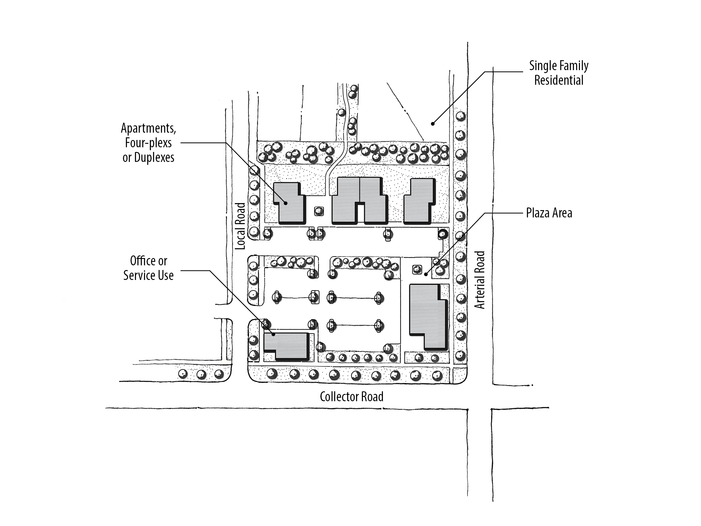
Mixed Use Non-Residential (MU-NR)
The purpose of this designation is to designate areas where new residential dwellings will not be permitted, as residential uses are not compatible with the planned and/or existing uses in these areas. For example, MU-NR areas are used near the City’s Wastewater Resource Recovery Facility and where there are heavy industrial or other hazardous operations that need to be buffered from residential. Developments are encouraged to be designed similar to the conceptual MU-NR plan depicted in Figure 3E.
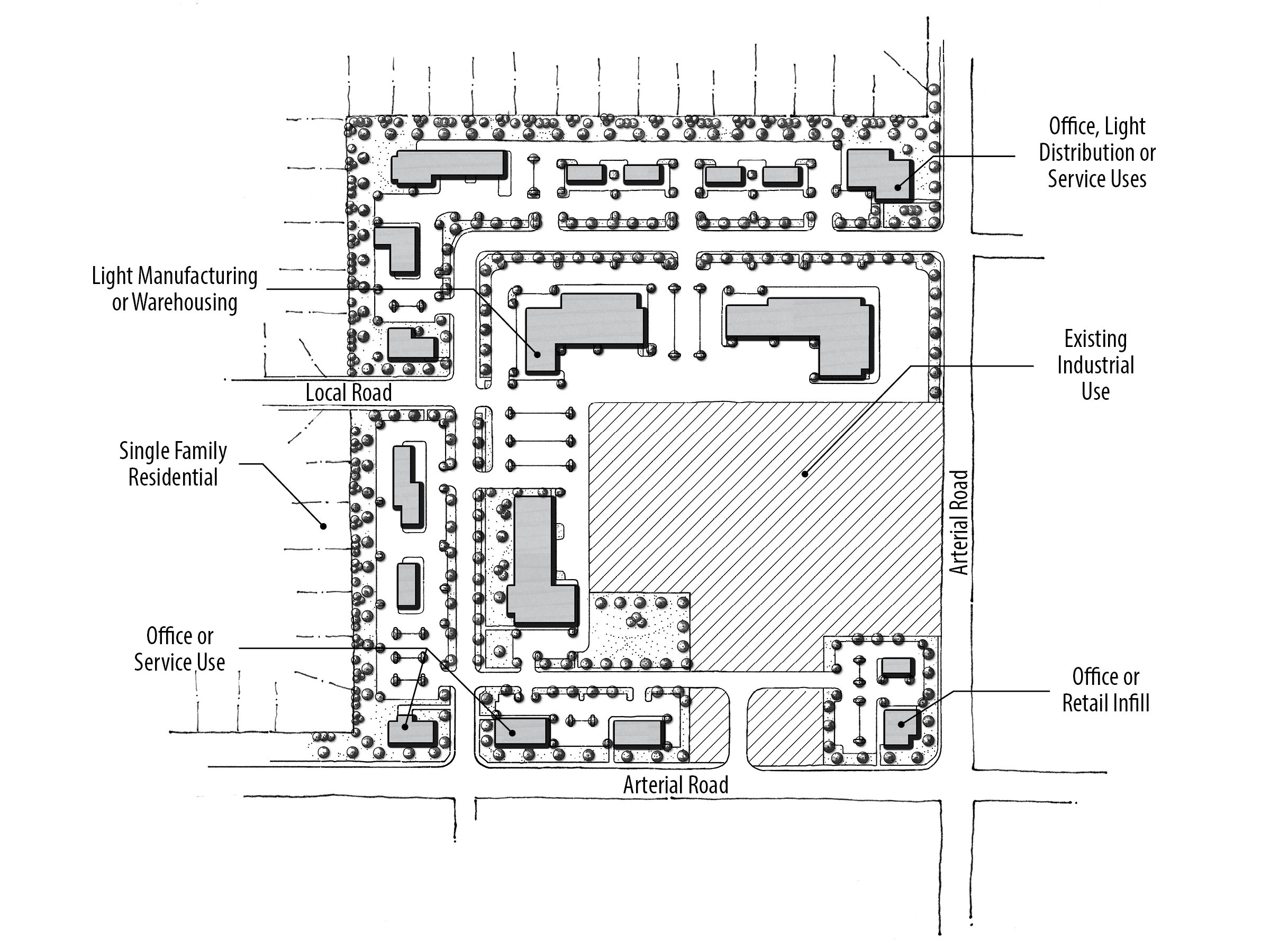
In reviewing development applications, the following items will be considered in MU-NR areas:
- No new residential uses will be permitted (existing residential may remain).
- All developments should have a mix of at least two types of land uses.
- Development is not required to comply with the minimum number of uses in the general mixed use standards.
- Street sections consistent with the Ada County Highway District Master Street Map are required within the Unified Development Code.
- There is neither a minimum nor maximum imposed on non-retail commercial uses such as office, food service/restaurants, industry, or warehouse uses.
- A transitional use is encouraged on the perimeter of the MU-NR areas between any existing or planned residential development.
Sample uses, appropriate in MU-NR areas would include: employment centers, professional offices, flex buildings, warehousing, industry, storage facilities and retail, and other appropriate non-residential uses. Sample zoning include: C-C, C-G, L-O, M-E, H-E, I-L, and I-H.
Mixed Use Interchange (MU-I)
The purpose of this designation is to call-out areas where construction of future SH-16 interchanges is likely to occur, and to acknowledge that this land will have a high degree of visibility. These areas will be served by highway interchange ramps and restricted local access. There are two interchange areas, one located at US 20-26 and one at Ustick Road, that differ from the other Mixed Use categories in that a much stronger emphasis will be placed upon gateway elements and traffic flow/trip generation factors when reviewing new land use applications. Uses in these areas will need to be compatible with the impacts of a freeway interchange. These areas are not intended for high volume uses such as retail. The intention is to protect the immediate vicinity of the interchange from traffic conflicts and shift the high traffic-generating uses away from the immediate vicinity of the interchange.
In reviewing development applications, the following items will be considered in MU-I areas:
- Land uses within the MU-I areas and adjacent to the SH-16 corridor should be carefully examined for their potential impacts on nearby existing and planned retail and restaurant in Commercial and Mixed Use areas.
- A traffic impact study may be required for larger developments in these areas.
- Vehicular access points are prohibited near interchange ramps. Future uses should be planned to integrate with a frontage/backage road type circulation system.
- Any new development at or near MU-I areas should promote a nodal development pattern where buildings are clustered, off-street parking is screened in the rear of the parcel and, where practical, development is inter-connected with adjoining parcels.
- The SH-16/US 20-26 interchange will be one of only two regional gateways to the City of Meridian for travelers coming from north of the Boise River (the other being Linder Road). As such, buildings, landscaping, and other design features at this interchange should reflect Meridian’s heritage, quality, and character.
- Regional ridesharing, park-and-ride and transit transfer facilities are strongly encouraged.
- The MU-I area at Ustick Road, west of SH-16, should minimize retail and auto-oriented services and transition rapidly from the interchange to residential uses near the county line.
- Examples of uses include schools, post office or library branches, office uses, light residential developments, athletic clubs, and technology/research parks.
TEN MILE INTERCHANGE SPECIFIC AREA PLAN
The City developed a specific plan for approximately 2,800 acres bordered (roughly) by Linder Road to the east; McDermott Road to the west: the Union Pacific Railroad line to the north and ½ mile south of Overland Road on the south. The specific area plan is an addendum to this Comprehensive Plan and places an emphasis on a mix of uses, both residential and commercial; new employment areas; higher density residential; a planned collector road network and design guidelines.
It is important to note that the Ten Mile Interchange Specific Area Plan (TMISAP) uses different land use designations than the rest of the FLUM. While there are some similarities, for example Low Density Residential, there are also new designations which do not exist outside of this Ten Mile area. The TMISAP was adopted as an addendum to the City of Meridian Comprehensive Plan on June 19th, 2007 by Resolutions Numbers 07-563 (Map) and 07-564 (Text). Development in the Ten Mile Interchange area will also be reviewed using the TMISAP. See the Ten Mile Interchange Specific Area Plan for more details of this area.
CIVIC LAND USES
The purpose of this designation is to preserve and protect existing and planned municipal, state, and federal lands for area residents and visitors. This category includes public lands, law enforcement facilities, post offices, fire stations, cemeteries, public utility sites, public parks, public schools, and other government owned sites within the Area of City Impact.
PARK LAND USES (SYMBOL)
The purpose of this designation is to preserve and protect existing and future public neighborhood, community, regional, and urban parks. The park locations designated on the Future Land Use Map are the most current and should be used for planning purposes. Constructed parks are further described in the Existing Conditions Report Addendum.
SCHOOL LAND USE (SYMBOL)
The purpose of this designation is to provide areas throughout the Area of City Impact which provide educational opportunities, community gathering places, and green space.
FIRE AND POLICE STATIONS (SYMBOL)
The purpose of this designation is to preserve and protect existing and planned fire and police station locations throughout the Area of City Impact which provide efficient emergency response.
ENTRYWAY CORRIDORS
The City feels it is important to identify roadways that introduce and welcome both visitors and residents to the City of Meridian. These roadways are noted as entryway corridors on the FLUM and are subject to additional standards within the Unified Development Code.
TRANSIT STATIONS AND TRANSIT ORIENTED DEVELOPMENT (SYMBOL)
The Transit Station designation is used for areas where transit supported uses are envisioned along the railroad and other predefined corridors Within areas around these symbols, the City seeks projects that incorporate features which enhance alternative transportation and are transit friendly. Said developments are envisioned within commercial activity centers and should incorporate the following development and design principles:
- A mix of land uses
- Building orientation that provides the maximum level of services to pedestrians, bicyclists and transit users
- Alternative transit features such as a bus shelter (where approved by VRT), bicycle lockers or similar facilities
- Residential densities that are at least 8 dwelling units per acre and designed to comply with the Traditional Neighborhood design standards in the Unified Development Code
- Park and ride lots and other transit-supportive facilities are encouraged at interchanges throughout the City. VRT and ACHD Commuteride should be partners in determining appropriate facilities at each interchange.
- New types of street cross sections, including multi-purpose pathways, buffered bike lanes and managed lands that can accommodate new forms of vehicles from electric bicycles, scooters, autonomous vehicles and future dedicated transit.

UTILITIES AND INFRASTRUCTURE
INTRODUCTION
Utilities are the foundation to quality of life within cities. Clean drinking water, electricity, stormwater management, natural gas, telecommunications, and wastewater make city-living possible. Adequate, efficient, accessible, and affordable utilities contribute to attracting business, reducing the environmental footprint of urban development, and playing a vital role in social development. Public facilities discussed in this section include domestic water service, sewer collection, sewage treatment, and other independently operated utilities (such as power, natural gas, and communications). The Utilities Element works in concert with the Growth and Land Use Elements to ensure adequate infrastructure is in place to accommodate existing and future needs.
BACKGROUND
The City owns and operates its own domestic water and sewer services; however it relies on other entities for some of the other essential services. Therefore, coordination between the City and each service provider is vital in planning and prioritizing of expansion areas, and continued service to existing locations.
With the exception of a portion of north Meridian where SUEZ Water provides service, the City’s Public Works Department provides water to Meridian residents. In order to keep up with water demand, new wells and water line extensions are constructed and generally funded by new development.
With a vision for sustainability, Meridian works to conserve ground water and reduce discharge flows into the Boise River. As Meridian is located in an arid climate, using recycled water is a “drought-proof” water supply that reduces demand on municipal supply, frees up agricultural water for agricultural uses, and lowers effluent flow to the Boise River.
Water Service
The City’s domestic water system is currently supported by a series of deep wells, booster pump stations, multiple reservoirs, and pipeline. In order to keep up with water demand, the City has constructed, on average, one new well per year, each funded by connection fees and charged to new development. Water line extensions to new developments are generally paid for and constructed by developers. Although the City plans new wells and reservoirs, the specific locations to those facilities are largely dictated by growth patterns, and will continue to be funded by new development. In a few small areas of the City, SUEZ provides water service to residents and businesses, and new development must coordinate this service with both the City of Meridian and with SUEZ.
Sewer Collection & Treatment
The sewer (also known as wastewater) collection system in the City consists of pipe and lift (pump) stations. Sewage generally flows by gravity to the Wastewater Resource Recovery Facility located northwest of the Ten Mile/Ustick intersection. The Sewer Master Plan includes development of a computer model which helps Public Works staff identify priority areas for development in the City as well as segments of the existing sewage collection system that are approaching capacity. Future capital improvements are prioritized to upgrade the lines that are approaching capacity. The City will evaluate the need for additional expansion projects based on the Sewer Master Plan and model.
The Wastewater Resource Recovery Facility (WRRF) consists of primary, secondary, and tertiary treatment followed by disinfection. Treated effluent is discharged to Five Mile Creek. The City continues to upgrade the facility following its current Facility and 5 year Capital Improvement Plans. This facility is regulated by a National Pollutant Discharge Elimination System (NPDES) Wastewater discharge permit from the Environmental Protection Agency (EPA).
With a vision for sustainability, Meridian holds a Citywide Class A Recycled Water Permit. Recycled water is a highly treated water resource generated at the WRRF that meets standards for reuse, as established by the Idaho Department of Environmental Quality. The WRRF makes this recycled water available free of charge in supported areas.
Garbage and Recycling
Republic Services (Republic) is the solid waste and recycling collection contractor for the City of Meridian. Republic is dedicated to providing reliable and innovative recycling and waste reduction programs to the City. The City has established a Solid Waste Advisory Committee (SWAC) to help set steer a curbside recycling program and to advise the City Council on other solid waste issues. The SWAC works in conjunction with Republic staff. The SWAC focuses its attention on growing the solid waste and recycling programs and making them as user friendly as possible.
Irrigation
Meridian irrigation water is largely supplied by a series of canals and laterals diverted from the Boise River. There are many irrigation districts with operations in Meridian’s Area of City Impact, but the two largest affecting most of Meridian are the Settler’s Irrigation District and Nampa and Meridian Irrigation District (NMID).
Power
Idaho Power Company provides electrical services throughout the City of Meridian and its Area of City Impact. Idaho Power is a public service company regulated by the Idaho Public Utility Commission (IPUC), the Federal Energy Regulatory Commission (FERC), and the state regulatory commissions of Idaho and Oregon. Idaho Power’s long-range electrical plan for Meridian and the larger area is called the Eastern Treasure Valley Electrical Plan, which is listed in the adopted by reference section of this Plan.
Natural Gas
Intermountain Gas Company is the sole provider of natural gas in southern Idaho, including Meridian. Meridian is serviced by dual, high pressure natural gas pipelines that bisect the southwest part of the Area of City Impact. These lines are an important consideration for any development adjacent to them.
Communications
Sparklight and CenturyLink provide landline phone and cable television agreements in the area. Sparklight (formerly CableOne) has a franchise agreement with the City for traditional cable T.V. services. There are also a number of other fiber and wireless providers which also offer telecommunication services.
For additional information, refer to the following resources:
- Existing Conditions Report; Addendum to the City of Meridian Comprehensive Plan | City of Meridian Webpage
- Meridian Water Master Plan | City of Meridian Webpage
- Meridian Water Conservation Plan | PDF
- Meridian Collection System Master Plan | City of Meridian Webpage
- Eastern Treasure Valley Electric Plan | External Website
- Environmental Programs Plan | City of Meridian Webpage
Policy Table
Policies by Topic
| ID | Policy | Section | Section Symbols | Type | Chapter | Priority | Lead | Support |
|---|---|---|---|---|---|---|---|---|
| 3.00.00 | Chapter 3 | Evolving Community | \ > D | 3 | ||||
| 3.01.00 | Recognize that Meridian's population will continue to grow and positively foster Meridian's continued growth. | Growth and Population | \ | G | 3 | CD | All | |
| 3.01.01 | Provide facilities and services that maintain a premier level of service commensurate with growth. | Growth and Population | \ | O | 3 | CD | All | |
| 3.01.01A | Evaluate comprehensive impacts of growth and consider City Master Plans and Strategic Plans in all land use decisions (e.g., traffic impacts, school enrollment, and parks). | Growth and Population | \ | A | 3 | On-going | CD | All |
| 3.01.01B | Update the Comprehensive Plan and Unified Development Code as needed to accommodate the community's needs and growth trends. | Growth and Population | \ | A | 3 | On-going | CD | |
| 3.01.01C | Ensure that regulations and plans support and encourage desired development and land use patterns within the Area of City Impact. | Growth and Population | \ | A | 3 | On-going | CD | |
| 3.01.01D | Evaluate development proposals based on consistency with the vison as well as physical, social, economic, environmental, and aesthetic criteria. | Growth and Population | \ | A | 3 | High | CD | |
| 3.01.01E | Coordinate with the City of Nampa, Canyon County, Star, Eagle, Kuna, Boise, and Ada County on land use, transportation, and emergency services. | Growth and Population | \ | A | 3 | On-going | CD | All |
| 3.02.00 | Maintain, improve, and expand the City's infrastructure to meet existing and growing demands in a timely, orderly, and logical manner. | Growth and Population | \ | G | 3 | FI, MO, PW | All, CD, FI, HR | |
| 3.02.01 | Develop and implement master plans for all public facilities, services, and safety to guide the growth of the City. | Growth and Population | \ | O | 3 | FI, MO, PW | All, CD, FI, HR | |
| 3.02.01A | Provide City utilities in high priority growth areas and discourage in low priority growth areas. | Growth and Population | \ | A | 3 | On-going | PW | |
| 3.02.01B | Protect investments in existing public facilities (water, sewer, streets, fire, police, etc.) by ensuring extension of services by new development is in the best interest of the City. | Growth and Population | \ | A | 3 | On-going | PW | CD |
| 3.02.01C | Utilize preferred methods of communication with citizens and engage their input on public facilities planning, construction, and funding. | Growth and Population | \ | A | 3 | On-going | PW | |
| 3.02.01D | Support the appropriate expansion of City facilities, services, staff, and other resources to keep up with demand and established levels of service. | Growth and Population | \ | A | 3 | On-going | PW | CD, FI, HR |
| 3.02.01E | Phase-in developments in accordance with their connection to the municipal sewer and water system and the provision of other necessary infrastructure and services. | Growth and Population | \ | A | 3 | On-going | PW | CD |
| 3.02.01F | Maintain an efficient and fair system of fees and development requirements that assesses the costs and benefits of financing public facilities and services, the need for which is generated by new development. | Growth and Population | \ | A | 3 | On-going | FI | CD, PW |
| 3.02.01G | Establish and maintain levels of service for public facilities and services, including water, sewer, police, transportation, schools, fire, and parks. | Growth and Population | \ | A | 3 | High | MO | All |
| 3.03.00 | Direct and prioritize development in strategic areas and in accordance with corridor and special area plans. | Growth and Population | \ | G | 3 | CD, PW | All, CD, AO, PW | |
| 3.03.01 | Plan for an appropriate land use mix, recreational and civic facilities, and phased service extension within specific area plans and urban renewal districts. | Growth and Population | \ | O | 3 | CD, PW | All, CD | |
| 3.03.01A | Continue to develop and implement the desired vision in special areas, areas with specific plans, and along key transportation corridors. | Growth and Population | \ | A | 3 | On-going | CD | |
| 3.03.01B | Actively engage with City leadership and community members to explore the idea, process, and potential impacts of implementing districts, subareas, neighborhood association areas, or similar concepts. | Growth and Population | \ | A | 3 | On-going | CD | |
| 3.03.01C | Consider developing new subarea plans as appropriate for areas with unique characteristics, public/private partnerships in place, and that are compatible with Comprehensive Plan policies in order to provide additional guidance on future land uses, design, infrastructure, and amenities. | Growth and Population | \ | A | 3 | Very High | CD | All |
| 3.03.01D | Ensure that adequate water supply and pressure are available for fire protection in areas suitable for industrial and commercial uses. | Growth and Population | \ | A | 3 | On-going | PW | |
| 3.03.01E | Encourage infill development. | Growth and Population | \ | A | 3 | High | CD | |
| 3.03.02 | Prioritize growth and development where it furthers the City's vision and allows for the efficient provision of services. | Growth and Population | \ | O | 3 | CD, PW | All, CD | |
| 3.03.02A | Engage with service providers, City leadership, and community members to identify priority growth areas. | Growth and Population | \ | A | 3 | Very High | CD | All |
| 3.03.02B | Focus future investments within established priority growth areas. | Growth and Population | \ | A | 3 | On-going | CD | All |
| 3.03.02C | Utilize the City's Service Impact Tool to help identify potential strategic growth areas. | Growth and Population | \ | A | 3 | On-going | CD | All |
| 3.03.02D | As part of establishing and implementing strategic growth areas, consider including targeted redevelopment/opportunity areas within the Area of City Impact, areas within the City limits and within a specified distance of major utility connections, and unincorporated county enclaves suitable for annexation. | Growth and Population | \ | A | 3 | Very High | CD | All |
| 3.03.02E | Develop incentives for appropriate investment in strategic growth areas; discourage development outside of established growth areas. | Growth and Population | \ | A | 3 | Very High | CD | All |
| 3.03.02F | Require proposed development within areas further away from urban services, existing utilities or requiring significant City utility upgrades, to demonstrate fiscal benefits, strategic fit with the Comprehensive Plan, contiguity with existing development, and appropriate mitigation for any impacts to existing City service users. | Growth and Population | \ | A | 3 | On-going | CD | |
| 3.03.02G | Build and provide services in a manner that promotes the vision of priority growth areas, reinforcing and protecting Meridian's growth objectives. | Growth and Population | \ | A | 3 | On-going | PW | CD |
| 3.03.02H | Require rural area residential development to submit alternative development plan to allow for the efficient extension of urban services in the future (resubdivision plan). | Growth and Population | \ | A | 3 | On-going | PW | CD |
| 3.03.03 | Annex lands into the corporate boundaries of the City only when the annexation proposal conforms to the City's vision and the necessary extension of public services and infrastructure is provided. | Growth and Population | \ | O | 3 | PW, CD | CD, All | |
| 3.03.03A | Ensure development is connected to City of Meridian water and sanitary sewer systems and the extension to and through said developments are constructed in conformance with the City of Meridian Water and Sewer System Master Plans in effect at the time of development. | Growth and Population | \ | A | 3 | On-going | CD | PW |
| 3.03.03B | Implement an irrevocable consent to annexation as a condition of hook-up to City sanitary sewer or water and make a deed restriction on all buildable lots to be placed as a note on all final plats. | Growth and Population | \ | A | 3 | On-going | PW | CD |
| 3.03.03C | Require all City sewer and water inspections and plan review fees (for the main lines) in effect at the time of development be paid to the City of Meridian. | Growth and Population | \ | A | 3 | On-going | PW | CD |
| 3.03.03D | Require all development to be consistent with Future Land Use Map designations for the property. | Growth and Population | \ | A | 3 | On-going | CD | |
| 3.03.03E | Require all development to be contiguous to the City. | Growth and Population | \ | A | 3 | On-going | CD | |
| 3.03.03F | Permit new development only where it can be adequately served by critical public facilities and urban services at the time of final approval, and in accord with any adopted levels of service for public facilities and services. | Growth and Population | \ | A | 3 | On-going | CD | All |
| 3.03.03G | Require urban infrastructure be provided for all new developments, including curb and gutter, sidewalks, water and sewer utilities. | Growth and Population | \ | A | 3 | On-going | CD | |
| 3.03.03H | Evaluate both the short and longer-term fiscal and environmental impacts of annexing lands. | Growth and Population | \ | A | 3 | On-going | CD | All |
| 3.03.03I | Evaluate the feasibility of annexing existing county enclaves and discourage the creation of additional enclaves. | Growth and Population | \ | A | 3 | On-going | CD | |
| 3.03.03J | Encourage the assembly of parcels for master planning, design and entitlement purposes; discourage piecemeal annexation and development. | Growth and Population | \ | A | 3 | On-going | CD | |
| 3.03.04 | Plan for transportation connectivity and the provision of adequate urban utilities and services for county enclaves. | Growth and Population | \ | O | 3 | CD | AO, PW | |
| 3.03.04A | Plan for connectivity between annexed parcels and county enclaves that may develop at a higher intensity. | Growth and Population | \ | A | 3 | On-going | CD | |
| 3.03.04B | Ensure existing county enclaves provide necessary urban-level transportation and utility infrastructure as part of the annexation process. | Growth and Population | \ | A | 3 | On-going | CD | PW |
| 3.03.04C | Consider the establishment of improvement districts, extra-ordinary impact fee areas, and other funding mechanisms to provide the necessary urban infrastructure and services for existing county enclaves. | Growth and Population | \ | A | 3 | High | CD | AO, PW |
| 3.04.00 | Shape the future of the City through implementation and coordination of long range planning efforts. | Growth and Population | \ | G | 3 | CD, IT, MO | All, CD, PW | |
| 3.04.01 | Advance, support, and promote development of City planning tools, including the Comprehensive Plan, City ordinances, plans, and other guiding documents that execute the City's vision. | Growth and Population | \ | O | 3 | CD, IT, MO | All, PW | |
| 3.04.01A | Promote the Comprehensive Plan as the primary guide for growth and development of the community. | Growth and Population | \ | A | 3 | On-going | CD | |
| 3.04.01B | Maintain and update the Unified Development Code and Future Land Use Map to implement the provisions of this Comprehensive Plan. | Growth and Population | \ | A | 3 | On-going | CD | |
| 3.04.01C | Support and expand the capabilities of all City Departments and Staff to better serve the community. | Growth and Population | \ | A | 3 | On-going | MO | All |
| 3.04.01D | Maintain, update, and find better ways to use Geographic Information Systems (GIS) in everyday City business and for project-specific purposes. | Growth and Population | \ | A | 3 | On-going | IT | All, PW |
| 3.04.01E | Monitor the progress of the Comprehensive Plan implementation plan to ensure steady progress. | Growth and Population | \ | A | 3 | On-going | CD | |
| 3.04.01F | Review the policies within the adopted Comprehensive Plan on a regular basis and update as needed to ensure that they reflect, support, and advance the City's vision. | Growth and Population | \ | A | 3 | On-going | MO | All |
| 3.04.01G | Participate in planning efforts with COMPASS and affiliated local governments and agencies to better coordinate planning policies regionally. | Growth and Population | \ | A | 3 | On-going | CD | PW |
| 3.04.01H | Organize and fund committees or special commissions consistent with the provisions of this Comprehensive Plan. | Growth and Population | \ | A | 3 | On-going | MO | All |
| 3.04.01I | Enforce the Unified Development Code and all other City ordinances and ensure their alignment with the Comprehensive Plan. | Growth and Population | \ | A | 3 | On-going | CD | |
| 3.04.02 | Engage and inform the public about land use planning processes. | Growth and Population | \ | O | 3 | CD, MO | CD | |
| 3.04.02A | Solicit public participation in the land use and entitlement process through a variety of digital and in person methods. | Growth and Population | \ | A | 3 | On-going | CD | |
| 3.04.02B | Hold public meetings in conjunction with updates to the Comprehensive Plan to promote a better understanding of the plan and its purpose. | Growth and Population | \ | A | 3 | On-going | MO | CD |
| 3.04.02C | Convey the Comprehensive Plan's legal elements and intent by informing and educating the public, agencies and service providers, advisory boards and other stakeholders to improve the overall planning process. | Growth and Population | \ | A | 3 | On-going | CD | |
| 3.04.02D | Improve the neighborhood meeting and public notice process. | Growth and Population | \ | A | 3 | Very High | CD | AO |
| 3.05.00 | Ensure that all planning, zoning and land use decisions balance the interests of the community by protecting private property rights for current citizens and future generations. | Growth and Population | \ | G | 3 | AO | CD | |
| 3.05.01 | Enact land use ordinances, policies, and fees, and make decisions, including land use restrictions and conditions of approval, that do not violate private property rights. | Growth and Population | \ | O | 3 | AO | CD | |
| 3.05.01A | Conduct regular training with City Council, Planning & Zoning Commission, and City staff to ensure that Idaho Code section 67-8003 is properly applied in land use planning and development review processes. | Growth and Population | \ | A | 3 | On-going | AO | CD |
| 3.05.01B | Regularly review policies, the Unified Development Code, and other City regulations for consistency with Idaho Code. | Growth and Population | \ | A | 3 | On-going | AO | CD |
| 3.05.01C | Preserve private property rights and values by enforcing regulations that will prevent and mitigate against incompatible and detrimental neighboring uses. | Growth and Population | \ | A | 3 | On-going | AO | CD |
| 3.06.00 | Ensure a variety and balance of land uses within the Area of City Impact. | Future Land use | > | G | 3 | CD | MO, PW | |
| 3.06.01 | Plan for periodic review, monitoring, and updating of land uses within City limits and Area of City Impact. | Future Land use | > | O | 3 | CD | MO | |
| 3.06.01A | Maintain the Future Land Use Map to reflect existing facilities. | Future Land use | > | A | 3 | On-going | CD | |
| 3.06.01B | Monitor and adjust the amount and mix of industrial, commercial, and office areas needed to meet the employment needs of the City. | Future Land use | > | A | 3 | High | CD | |
| 3.06.01C | Coordinate with Ada County to ensure all applicable land use ordinances and provisions of this Plan are recognized when development within the Area of City Impact but outside City Limits is proposed. | Future Land use | > | A | 3 | On-going | CD | MO |
| 3.06.02 | Plan for an appropriate mix of land uses that ensures connectivity, livability, and economic vitality. | Future Land use | > | O | 3 | CD | PW | |
| 3.06.02A | Support the inclusion of small-scale neighborhood commercial areas within planned residential developments as part of the development plan, where appropriate. | Future Land use | > | A | 3 | On-going | CD | |
| 3.06.02B | Encourage and support mixed-use areas that provide the benefits of being able to live, shop, dine, play, and work in close proximity, thereby reducing vehicle trips, and enhancing overall livability and sustainability. | Future Land use | > | A | 3 | On-going | CD | |
| 3.06.02C | Encourage the development of supportive commercial near employment areas. | Future Land use | > | A | 3 | On-going | CD | |
| 3.06.02D | Plan for industrial areas with convenient access to state highways or the rail corridor, where appropriate. | Future Land use | > | A | 3 | On-going | CD | |
| 3.06.02E | Discourage residential land uses in close proximity to the Wastewater Resource Recovery Facility, the Intermountain Gas Facility on Can-Ada Road, and other incompatible land uses. | Future Land use | > | A | 3 | High | CD | PW |
| 3.06.02F | Allocate land uses near the rail corridor to both support industrial and freight movement but also residential and the movement of people within the corridor. | Future Land use | > | A | 3 | On-going | CD | |
| 3.07.00 | Encourage compatible uses and site design to minimize conflicts and maximize use of land. | Future Land use | > | G | 3 | CD | PR | |
| 3.07.01 | Proactively address potential conflicts between incompatible uses. | Future Land use | > | O | 3 | CD | ||
| 3.07.01A | Require all new development to create a site design compatible with surrounding uses through buffering, screening, transitional densities, and other best site design practices. | Future Land use | > | A | 3 | On-going | CD | |
| 3.07.01B | Encourage land uses and site designs that do not harm natural systems and resources. | Future Land use | > | A | 3 | On-going | CD | |
| 3.07.01C | Require appropriate landscaping, buffers, and noise mitigation with new development along transportation corridors (setback, vegetation, low walls, berms, etc.). | Future Land use | > | A | 3 | On-going | CD | |
| 3.07.01D | Preserve the industrial base within designated industrial land use areas by discouraging non-industrial uses and focusing on light manufacturing, distribution, flex-space, and base-employment. | Future Land use | > | A | 3 | High | CD | |
| 3.07.01E | Where feasible, encourage large transmission and pipeline utility corridors to function as transitional buffers, parkland, pathways, and gathering spaces within and adjacent to their right of way. | Future Land use | > | A | 3 | On-going | CD | |
| 3.07.02 | Integrate land use and transportation planning to ensure that they mutually support the communities' goals and desires. | Future Land use | > | O | 3 | CD | PR | |
| 3.07.02A | Require pedestrian circulation plans to ensure safety and convenient access across large commercial and mixed-use developments. | Future Land use | > | A | 3 | On-going | CD | |
| 3.07.02B | Locate smaller-scale, neighborhood-serving commercial and office use clusters so they complement and provide convenient access from nearby residential areas, limiting access to arterial roadways and multimodal corridors. | Future Land use | > | A | 3 | On-going | CD | |
| 3.07.02C | Focus development and redevelopment intensity on key transportation corridors. | Future Land use | > | A | 3 | On-going | CD | |
| 3.07.02D | Pursue transit-supportive densities of residential and employment uses along key multi-modal corridors. | Future Land use | > | A | 3 | On-going | CD | |
| 3.07.02E | Explore the development of additional design guidelines or standards for transit-oriented development. | Future Land use | > | A | 3 | On-going | CD | |
| 3.07.02F | Coordinate with transportation agencies to align future needed infrastructure with land use plans and implement through the development review processes. | Future Land use | > | A | 3 | On-going | CD | |
| 3.07.02G | Coordinate with transportation agencies, private property owners and the public to plan for appropriate land uses that will accommodate both freight and public transportation access within the rail corridor. | Future Land use | > | A | 3 | On-going | CD | |
| 3.07.02H | Integrate the Meridian Pathways Master Plan into the site development review process to ensure planned paths are built out as adjacent land develops. | Future Land use | > | A | 3 | On-going | CD | PR |
| 3.08.00 | Coordinate with service providers to ensure the long-term utility needs of Meridian's existing and future residents and businesses are met. | Utilities & Infrastructure | D | G | 3 | CD, PW, PR, MO | All, CD, IT, PW | |
| 3.08.01 | Plan and expand public utility facilities and services as part of the development process. | Utilities & Infrastructure | D | O | 3 | CD | All | |
| 3.08.01A | Require that development projects have planned for the efficient provision of all public services. | Utilities & Infrastructure | D | A | 3 | On-going | CD | All |
| 3.08.01B | Require adequate fees from new development to fund expansion of services. | Utilities & Infrastructure | D | A | 3 | On-going | CD | All |
| 3.08.01C | Ensure that other City departments, area agencies, and service providers are informed about and have an opportunity to participate in the City's development review process. | Utilities & Infrastructure | D | A | 3 | On-going | CD | All |
| 3.08.01D | Consider the impact on key service providers prior to acting on annexation requests at a public hearing. | Utilities & Infrastructure | D | A | 3 | On-going | CD | All |
| 3.08.01E | Ensure key service providers have provided written comment on the impact and potential mitigation measures that may be necessary, prior to acting on large development applications. | Utilities & Infrastructure | D | A | 3 | On-going | CD | All |
| 3.08.02 | Cooperate with other agencies and service providers around the Valley to continuously provide essential services and utilities to all residents. | Utilities & Infrastructure | D | O | 3 | PW, PR, MO | CD, IT, PW | |
| 3.08.02A | Communicate planning efforts with local decision makers and utility service providers, including irrigation districts, energy, natural gas, solid waste, and telecommunications. | Utilities & Infrastructure | D | A | 3 | On-going | PW | CD |
| 3.08.02B | Coordinate with developers, irrigation districts, and drainage entities to implement the proposed pathway network along canals, ditches, creeks, laterals and sloughs. | Utilities & Infrastructure | D | A | 3 | Very High | PR | CD |
| 3.08.02C | Regularly coordinate with other public utilities and essential service providers and annually review master plans for public facilities and services; update as needed. | Utilities & Infrastructure | D | A | 3 | On-going | PW | CD |
| 3.08.02D | Coordinate with Idaho Power to make additions and improvements to their facilities so that adequate capacity for projected growth is realized. | Utilities & Infrastructure | D | A | 3 | On-going | CD | PW |
| 3.08.02E | Encourage the enhancement of the capacity and reliability of renewable energy resources. | Utilities & Infrastructure | D | A | 3 | On-going | PW | CD |
| 3.08.02F | Encourage multi-use utility corridors. | Utilities & Infrastructure | D | A | 3 | On-going | CD | PW |
| 3.08.02G | Support the expansion of and accessibility to high-speed internet and broadband throughout the Area of City Impact. | Utilities & Infrastructure | D | A | 3 | On-going | MO | IT, PW |
| 3.08.03 | Coordinate with utility providers on acceptable landscape materials, design and site locations for their future facilities to avoid negative impacts to the community. | Utilities & Infrastructure | D | O | 3 | CD | PW | |
| 3.08.03A | Minimize the impact of electric facilities in environmentally sensitive areas and consider social and environmental justice impacts. | Utilities & Infrastructure | D | A | 3 | On-going | CD | PW |
| 3.08.03B | Site utility corridors within identified or designated transportation corridors and ensure that they connect to similar facilities in adjacent jurisdictions. | Utilities & Infrastructure | D | A | 3 | On-going | CD | PW |
| 3.08.03C | Coordinate future placement of Idaho Power electrical transmission lines and substations in accordance with Eastern Treasure Valley Electric Plan. | Utilities & Infrastructure | D | A | 3 | On-going | CD | PW |
| 3.08.03D | Encourage all electrical distribution utilities to be located underground. | Utilities & Infrastructure | D | A | 3 | On-going | CD | PW |
| 3.09.00 | Maximize diversion of the municipal waste stream from disposal to recycling and reduce the amount of solid waste generated in the City. | Utilities & Infrastructure | D | G | 3 | PW | FI, AO, MO | |
| 3.09.01 | Develop and support markets for recycled materials and products. | Utilities & Infrastructure | D | O | 3 | PW | AO, MO | |
| 3.09.01A | Investigate opportunities with other jurisdictions and private refuse contractors for new waste reduction and recycling markets. | Utilities & Infrastructure | D | A | 3 | Medium | PW | AO |
| 3.09.01B | Establish solid waste fees that encourage waste reduction and recycling. | Utilities & Infrastructure | D | A | 3 | Low | PW | AO |
| 3.09.01C | Develop and implement public education and outreach activities to raise awareness on waste reduction, reuse, recycling, and hazardous waste reduction. | Utilities & Infrastructure | D | A | 3 | On-going | PW | MO |
| 3.09.02 | Establish recycling/diversion and hazardous waste disposal goals. | Utilities & Infrastructure | D | O | 3 | PW | ||
| 3.09.02A | Maintain opportunities for proper disposal of target priority waste streams such as mercury, used oil, fluorescent lamps, used gas, and waste tires. | Utilities & Infrastructure | D | A | 3 | On-going | PW | |
| 3.09.02B | Work with local stakeholders to develop public education campaigns regarding the importance of and opportunities for the proper disposal of hazardous waste. | Utilities & Infrastructure | D | A | 3 | On-going | PW | |
| 3.09.03 | Reinforce existing City recycling and procurement policies. | Utilities & Infrastructure | D | O | 3 | PW | FI | |
| 3.09.03A | Partner with City's solid waste contractor to investigate conservation options including composting, recycling, and green waste. | Utilities & Infrastructure | D | A | 3 | Medium | PW | |
| 3.09.03B | Maintain internal recycling and sustainability programs that procure specific recycled content and less hazardous materials. | Utilities & Infrastructure | D | A | 3 | On-going | PW | FI |
Note: The Policy Table above depicts policies for this Chapter only. Too review policies for the entire Plan, see the Implementation Table.


